
The magnetic field of the Earth is believed to be generated by convection in the outer core through a dynamo effect ("geodynamo"): fluid motion within a pre-existing magnetic field creates electric currents, which in turn induce a magnetic field that reinforces the pre-existing magnetic field. The resulting magnetic field resembles a dipole field, with the magnetic axis inclined by about 11 degrees to the Earth's rotational axis, and with also an off-set from the Earth's centre by 540 km to the northwest Pacific (SPENVIS). The solar wind then deforms this field into a drop-shaped configuration, compressed at the sun-facing side, and stretched into a million kilometers long tail at the nightside. Taking into account there are also some non-dipolar contributions from e.g. the ionosphere, the ring current,... the final shape of the true magnetic field is very complex and dynamic. Due to the chaotic movement of the core fluid, the Earth's magnetic field gradually changes over the years. The image underneath shows the horizontal direction of the magnetic field lines at the surface of the Earth for the period 1590-2010. The magnetic North and South poles are shown as blue and red stars, respectively. Note the change in location of the magnetic poles, the clips also show the change in the speed of movement. Where the lines are blue, the magnetic field dips into the Earth, where they are red it emerges from the Earth. The transition from red to blue, where the field lines are horizontal, is called the magnetic equator. Clips are available at CIRES/Geomagnetism - https://geomag.us/info/declination.html .
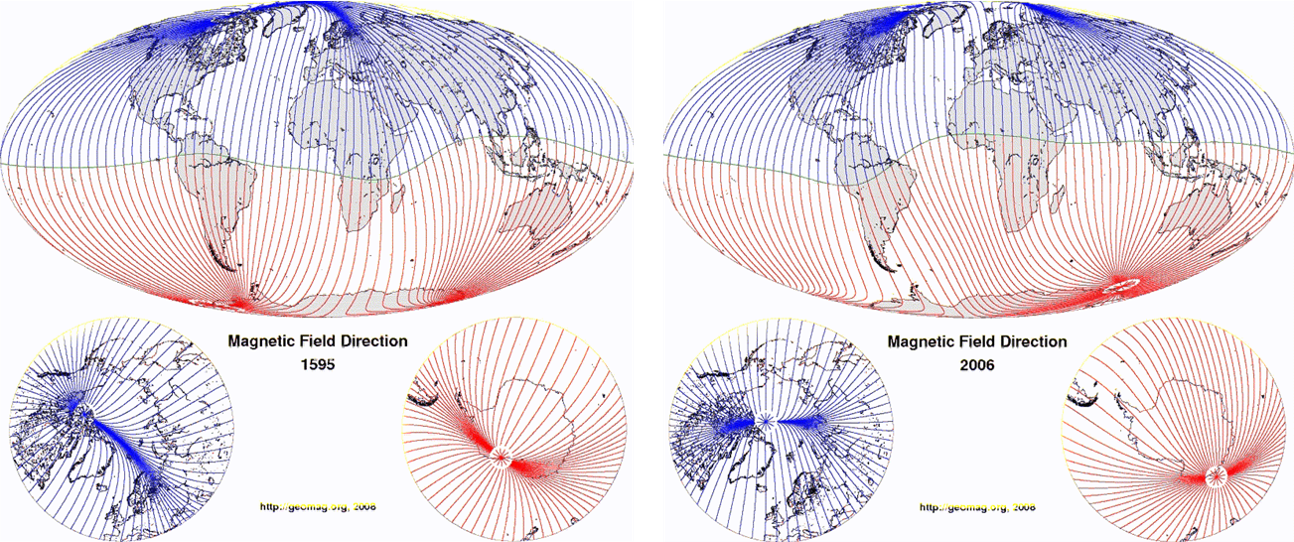
Credits: CIRES/Geomagnetism - https://geomag.us/info/declination.html
To study the geomagnetic field, several models such as for example the International Geomagnetic Reference Field (IGRF ; WDC for Geomagnetism at Kyoto), have been developed. The coefficients for the equations used in these models are determined experimentally by combining Earth-based and satellite measurements of the geomagnetic field. At the Earth's surface the main field can be approximated by a dipole placed at the Earth's centre and tilted to the axis of rotation by about 11 degrees. This is the so-called centred dipole model. If one takes also the 540 km off-set into account, the model is called the eccentric dipole model. The latter is often used when proxying the true Earth's magnetic field, and the associated poles are called the geomagnetic poles. Nonetheless, one should keep in mind that significant deviations from this dipole field model exist, both in location as in intensity (see BGS).
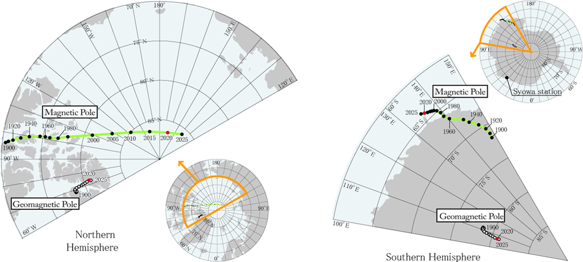
Credits: WDC for Geomagnetism Kyoto - https://wdc.kugi.kyoto-u.ac.jp/poles/polesexp.html
Thus, the location of these (modelled) geomagnetic poles differs from the true magnetic poles, the latter which are located where the magnetic field lines are perpendicularly entering (North pole) or leaving (South pole) the Earth's surface. Also known as the dip poles, these true magnetic poles are not antipodal, unlike their cousins of the dipole centred model. This can be seen in the maps above (WDC Kyoto) showing the locations for the northern and southern poles. The 2020 location of the North Magnetic Pole is 86.5° North and 162.9° East and the South Magnetic Pole is 64.1° South and 135.9° East (IGRF ; NCEI). From the above maps, it is clear that the location of these poles is not stable. Historic (100+ years) and paleomagnetic records (1 million years) clearly show that, in addition to polarity reversals, the magnetic poles have moved over time scales of decades to millions of years. This is called the "polar wander" (also known as "secular drift"), with the movement of the South Pole not being synchronous with that of the North Pole (Nagarajan, 2020).
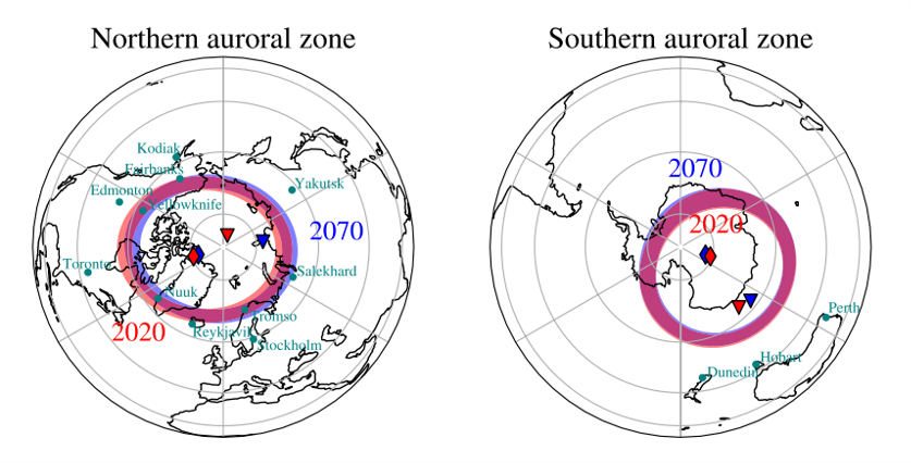
Credits: Maffei et al. 2023: https://www.nature.com/articles/s41598-022-25704-2
Recent decades have seen a remarkable acceleration of this secular drift of the dip pole in the Northern Hemisphere from Arctic Canada toward the coast of Eastern Siberia (Tsyganenko, 2019). As of present, the North dip pole has crossed the border between the western and eastern hemispheres, having passed only about 400 km from the North geographic pole. This drift is much smaller for the South dip pole. The effects of this drift of the North magnetic pole severely compromise the precision of direction finding of airport runways in the Northern Hemisphere (the "numbers" at the beginning and end of the runways), as well as navigation at high latitudes, precision surveys and drilling (Nagarajan, 2020). In view of such dramatic displacement, a natural question arises: how large and fast is the associated secular shift of the auroral ovals? Tsyganenko (2019) found that the secular shift of the auroral oval between 1965 and 2020 is about the same as that of the geomagnetic dipole axis, which is much slower than the fastly racing dip pole. In the Southern Hemisphere, the oval shifts are much smaller than in the Northern Hemisphere. Maffei et al. (2023) extended the current evolution to 2070, when the North dip pole would be located near Siberia. In the map above, auroral zones ("quiet" space weather conditions) for the 2020 (in red) and 2070 (in blue) epochs are displayed. The red and blue diamonds indicate the location of the geomagnetic poles at 2020 and 2070, respectively. The red and blue triangles indicate the location of the magnetic dip at 2020 and 2070, respectively. They concluded that, under these circumstances, it will be increasingly unlikely to spot aurorae in North American locations with the same latitudes as Edmonton (Canada) and Kodiak (Alaska), while it will be increasingly likely for locations such as Yakutsk, in Russia. Little change is expected for Europe, Australia and New Zealand.
For extreme space weather events, when the auroral ovals expand and move equatorially from their typical 65-70 degrees magnetic latitude to 50-60 degrees magnetic latitude, the results found by Maffei and his collaborators echo those found for the auroral zones. This can be seen in the map below, showing a near-side projection of the regions exposed to severe space weather events ("danger zones") for the 2020 (the orange bands) and 2070 (the cyan bands) epochs. In particular, there is little change in Northern Europe, with the Northern UK, Denmark and Scandinavia still remaining in these high-risk regions in 2070. Most notably, the high-risk band in North America moves northward, resulting in its southern edge shifting from approximately New York City in 2020 to Toronto in 2070. This northward change of the auroral and danger zones over North America will likely cause urban centres such as Edmonton and Labrador City (Canada) to be exposed by 2070 to the potential impact of severe solar activity. In the southern hemisphere, the largest predicted change of the high-risks bands is a motion towards South America in the Southern Atlantic Ocean. In the Indian and Pacific Ocean the changes are modest, with a small drift southward. In particular, the island of Tasmania and Southern New Zealand (including the city of Dunedin), will remain in the same risk region between 2020 and 2070, according to their forecast. To keep in mind: the measured magnetic fields are very sensitive to even small changes in the geodynamo (Livermore et al. 2020), which we can't predict, and so it is perfectly possible that within one or two decades the North dip pole is changing its course back to Canada, and all of the above was just a very nice thought experiment.
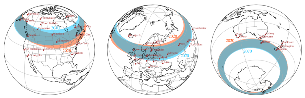
Credits: Maffei et al. 2023: https://www.nature.com/articles/s41598-022-25704-2
